Save this image free of charge
in 800 pixels for layout use
(right click, Save as...)
|
|
Ref : V01934
Theme :
Cyclones - Hurricanes - Storms - Clouds (438 images)
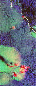
Title : Space radar image of Western Pacific rain clouds
Caption :
This radar image shows the ocean surface in a portion of the Western Pacific Ocean. Scientists are using images like this to study the occurrence, distribution and activity of tropical rain squalls and to understand the exchange of heat between the atmosphere and ocean and the upper layer mixing in the tropical oceans, which are critical factors for understanding the driving forces which produce the El Nino phenomenon. The white, curved area at the top of the image is a portion of the Ontong Java Atoll, part of the Solomon Islands group. The yellowish green area near the bottom of the image is an intense rain cell. This image is centered near 5.5 degrees South latitude and 159.5 degrees East longitude. The area shown is 50 kilometers by 21 kilometers (31 miles by 13 miles). This image was acquired by the Spaceborne Imaging Radar-C/X-Band Synthetic Aperture Radar (SIR-C/X-SAR) aboard the space shuttle Endeavour on its 13th orbit on April 10, 1994. The colors in the image are assigned to different frequencies and polarizations of the SIR-C radar as follows: Red is C-band horizontally transmitted and received; green is L-band horizontally transmitted and vertically received and blue is L-band horizontally transmitted and received. The large rain cell is about 15 kilometers by 15 kilometers (9 miles by 9 miles) and contains two dark regions, one circular and one rectangular, inside it. Two smaller reddish cells are visible closer to the atoll. The red areas may be caused by reflection from ice particles in the colder, upper portion of the storm cell and not from the ocean surface at all. This provides direct evidence that it is raining within this storm cell, valuable information which is usually very difficult to measure over more remote regions of the ocean away from coastal-based weather systems. The dark holes in the middle of the cell are thought to be areas of very heavy rainfall which actually smooth out the ocean surface and result in lower radar returns . The surrounding ocean is blue to green plus black. Winds and currents cause the ocean surface to be rough and those variations on the surface affect how the radar signals bounce off the surface. The bright areas on the image correspond to areas where the wind speed is high. The highest winds are seen as the yellow-green region of the large rain cell. The lowest winds are seen inside the atoll as dark areas. Outside the rain cell, the winds are moderately low, which is indicated by the puff-like, blue patterns surrounding the cell and extending into the atoll. The long, thin, dark lines extending across the ocean are surface currents. Here the currents are likely accumulating natural oils caused by small marine biological organisms. The oils cause the small, wind-generated waves to be reduced in size or damped which produces a smooth, dark zone on the radar image.
|
|

